
Archived information
The Standard on Web Usability replaces this content. This content is archived because Common Look and Feel 2.0 Standards have been rescinded.
Archived information is provided for reference, research or recordkeeping purposes. It is not subject to the Government of Canada Web Standards and has not been altered or updated since it was archived.
Notices to Mariners
July 29, 2022
Safety First, Service Always
Monthly Western Edition
CONTENTS
| Section 1 | General and Safety Information |
| Section 1A | Temporary and Preliminary Notices |
| Section 2 | Chart Corrections |
| Section 3 | Radio Aids to Marine Navigation Corrections |
| Section 4 | Canadian Sailing Directions Corrections |
| Section 5 | List of Lights, Buoys and Fog Signals Corrections |
Notices to Mariners – Monthly Western Edition
Edition No. 07/2022
Aussi disponible en français :
Avis aux navigateurs – Édition mensuelle de l’Ouest
Édition n° 07/2022
Published under the Authority of:
Canadian Coast Guard Programs
Aids to Navigation and Waterways
Fisheries and Oceans Canada
Montreal, QC H2Y 2E7
For more information, contact Notmar.XNCR@dfo-mpo.gc.ca.
© Her Majesty the Queen in Right of Canada,
as represented by the Minister of Fisheries, Oceans
and the Canadian Coast Guard, 2022.
Cat. No. Fs152-6E-PDF (Electronic PDF, English)
ISSN 1719-7708
Cat. No. Fs152-6F-PDF (Electronic PDF, French)
ISSN 1719-7716
Explanatory Notes – Notices to Mariners (NOTMAR)
Geographical positions refer directly to the graduations of the largest scale Canadian Hydrographic Service chart (unless otherwise indicated).
Bearings refer to the true compass and are measured clockwise from 000° (North) clockwise to 359°; those relating to lights are from seaward.
Visibility of lights is that in clear weather.
Depths - The units used for soundings (metres, fathoms or feet) are stated in the title of each chart.
Elevations are normally given above Higher High Water, Large Tide (unless otherwise indicated).
Distances may be calculated as follows:
1 nautical mile = 1,852 metres (6,076.1 feet)
1 statute mile = 1,609.3 metres (5,280 feet)
1 metre = 3.28 feet
Temporary and Preliminary Notices to Mariners – Section 1A of Notices to Mariners
These notices are indicated by a (T) or a (P), respectively. Please note that nautical charts are not amended by the Canadian Hydrographic Service for temporary (T) and preliminary (P) notices. It is recommended that mariners chart these corrections in pencil. For the list of charts affected by (T) & (P) notices, please refer to the current Notices to Mariners - Monthly Summary of Temporary and Preliminary Notices publication.
Suggestions and Corrections Form
This form is specifically for suggestions and corrections to Notices to Mariners publications. It is available online and also in fillable PDF format included with the monthly publication ZIP file.
To report chart discrepancies and/or corrections to the Canadian Sailing Directions booklets: Fill out the Marine Information Reporting Form and/or email chsinfo@dfo-mpo.gc.ca.
To report emergencies or navigational hazards: Contact your nearest MCTS centre
- VHF channel 16 (156.8 MHz)
- MF/HF frequency 2182 kHz/4125 kHz (where available)
- ∗16 on a cellphone (where available)
NOTMAR Website – Monthly Editions, Chart Corrections and Chart Patches
The NOTMAR website allows users to access the monthly publications,
chart corrections, and chart patches.
Users can subscribe for free to the email notification service
to receive notifications when charts of interest are updated, including their patches, as well as when a new Monthly Edition of Notices to Mariners is published.
In addition, the monthly publication and related
files to download, such as chart patches, can be obtained
all together through the download of a single ZIP file.
Explanatory Notes – Canadian Hydrographic Service (CHS)
Chart Corrections – Section 2 of Notices to Mariners
Corrections to nautical charts will be listed in numerical order by chart number. Each chart correction listed applies only to that particular chart. Related charts, if any, will have their own specific correction listed separately.
Users should also refer to CHS Chart 1: Symbols, Abbreviations and Terms for additional information pertaining to the correction of charts.
The illustration below describes the elements that will comprise a typical Section 2 chart correction:
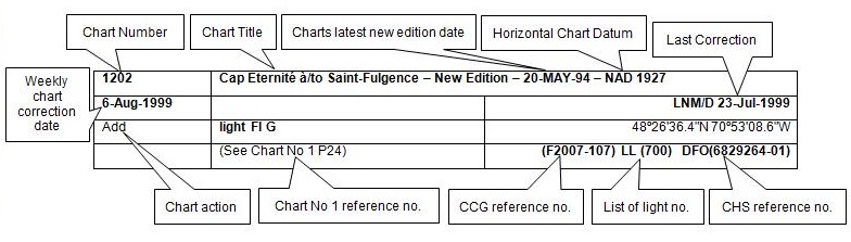
The last correction number is identified with the LNM/D or Last Notice to Mariners Number / Date.
Mariners are advised that only the most critical changes that directly affect safety to navigation are issued in “Section 2 – Chart Corrections.” This limitation is required to ensure that charts remain as clear and easy to read as possible. As a result, mariners may see minor discrepancies of a non-critical nature between information in official publications. For example, a small change in the nominal range or focal height of a light may not result in the production of a chart correction in Notices to Mariners, but may result in a correction in the List of Lights, Buoys and Fog Signals publication.
Note: In the case of a discrepancy between information provided on CHS charts relating to aids to navigation, and the List of Lights, Buoys and Fog Signals publication, the latter shall be deemed as containing the most up-to-date information.
Canadian Nautical Charts & Publications
A source list of Canadian nautical charts and publications is published in Notice No. 14 of the Notices to Mariners Annual Edition 2022. The source supply and the prices effective at the time of printing are listed. For current chart edition dates, please refer to the following website: www.chs-shc.gc.ca/charts-cartes/paper-papier/index-eng.asp
Explanatory Notes – Marine Communications and Traffic Services (MCTS)
Navigational Warnings / Notices to Shipping
The Canadian Coast Guard (CCG) is implementing a number of changes to the aids to navigation system in Canada.
These changes are advertised as Navigational Warnings, formerly called Notices to ShippingFootnote 1, that are broadcast by the CCG, and are then followed up with Notices to Mariners, then charts are updated by hand correction, reprints or new editions.
Mariners are advised that all relevant Navigational Warnings (NAVWARN) should be kept until superseded by Notices to Mariners or through revised charts issued by the Canadian Hydrographic Service (CHS).
NAVWARN are accessible on the applicable regional page on the CCG Navigational Warnings website at http://nis.ccg-gcc.gc.ca.
CHS is reviewing the impact of these changes with CCG and together are preparing an action plan on the issuing of chart revisions.
For further information, contact your regional NAVWARN Issuing Desk.
Western Region
Prince Rupert MCTS Centre
Canadian Coast Guard
Bag 4444
Prince Rupert, BC V8J 4K2
Telephone: 250-627-3070
Email: NAVWARN.MCTSPrinceRupert@innav.gc.ca
Website: http://www.marinfo.gc.ca/e-nav
Arctic Region
* Iqaluit MCTS Centre
Operational from approximately mid-May until late December.
Canadian Coast Guard
P.O. Box 189
Iqaluit, NU X0A 0H0
“A” Series
Telephone: 867-979-5269
“H” Series
Telephone: 867-979-0310
Facsimile: 867-979-4264
Email: NAVWARN.MCTSIqaluit@innav.gc.ca
Website: http://www.marinfo.gc.ca/e-nav
* Service available in English and French.
Index
Numerical Index of Canadian Charts Affected
This numerical index lists all nautical charts mentioned in this monthly edition of Notices to Mariners. Only charts appearing in Section 2 of this publication require a chart correction. The appearance of charts in all other sections, particularly those related to the correction of other nautical publications, is included here for reference.
| 3000 | 3478 | 3956 | 6035 |
| 3424 | 3539 | 3957 | 7487 |
| 3441 | 3545 | 3958 | 7565 |
| 3442 | 3546 | 3959 | 7566 |
| 3443 | 3547 | 3963 | 7750 |
| 3458 | 3548 | 3985 | 7778 |
| 3463 | 3549 | 3986 | |
| 3475 | 3934 | 3987 | |
| 3477 | 3947 | 4428 |
SECTION 1 - GENERAL AND SAFETY INFORMATION
Canadian Coast Guard Publication – Comments and Suggestions on Notices to Mariners (NOTMAR) Publications
In an effort to continuously improve the Notices to Mariners publications and to provide the most efficient service possible, the Notices to Mariners team invites all mariners and other interested parties to submit comments and suggestions on possible improvements to its various publications and services at the following email address: Notmar.XNCR@dfo-mpo.gc.ca.
Transport Canada – COVID-19 Measures, Updates and Guidance
(Recurrent publication of notice *401/20, originally published in the Notices to Mariners – Monthly Western Edition 04/2020 publication.)
Please refer to the link below for the latest updates to
transportation related measures taken by Transport Canada in
response to the evolving novel Coronavirus disease
(COVID-19):
https://www.tc.gc.ca/en/initiatives/covid-19-measures-updates-guidance-tc.html.
For travel advice and all other updates, please visit: Canada.ca/coronavirus.
West Coast Haida Gwaii – Voluntary Protection Zone for Shipping
(Recurrent publication of notice *1105/21, originally published in the Notices to Mariners – Monthly Western Edition 11/2021 publication.)
Reference: Notice *903/21 is cancelled.

Voluntary Protection Zone for Shipping, West Coast Haida Gwaii (formerly Queen Charlotte Islands)
Haida Gwaii’s remote location, rugged coastline, variable sea
and weather conditions, and rich ecological and cultural
heritage make it vulnerable to the potential for pollution
from shipping breakdowns and accidents. Increasing the
distance vessels travel offshore can increase the amount of
time available to address propulsion, steering or other
issues, and the likelihood of a towing vessel being able to
respond to a vessel that is disabled or drifting. This in
turn reduces the risk of grounding and oil spills.
A Voluntary Protection Zone for Shipping on the West Coast of
Haida Gwaii is currently in effect. In the Voluntary
Protection Zone, commercial vessels of 500 gross tonnage or
greater shall observe a minimum distance of 50 nautical miles
offshore when transiting along the West Coast of Haida Gwaii
with the following exceptions:
–Cruise vessels, to observe a minimum 12 nm distance from shore;
–Vessels transiting between Pacific Northwest ports
(Washington, Alaska, BC), to observe a minimum 25 nm distance
from shore;
–Tugs and barges (including pushing and towing
alongside), no minimum distance; and
–Fishing vessels, no minimum distance.
The Voluntary Protection Zone for Shipping coordinates are:
|
54⁰ 15.436' N |
133⁰ 04.788' W |
|
54⁰ 17.572' N |
134⁰ 02.484' W |
|
54⁰ 13.614' N |
134⁰ 19.427' W |
|
54⁰ 11.786' N |
134⁰ 30.841' W |
|
53⁰ 44.036' N |
134⁰ 32.677' W |
|
53⁰ 11.118' N |
134⁰ 16.412' W |
|
52⁰ 18.483' N |
133⁰ 20.917' W |
|
51⁰ 24.590' N |
132⁰ 04.081' W |
|
51⁰ 56.158' N |
131⁰ 01.830' W |
Vessels are requested to adhere to these distances on a voluntary basis and only when it does not jeopardize the safety of navigation, the vessel, the persons aboard, and the cargo.
(NW-P-1085-20)
Transport Canada – Annual Edition of Notices to Mariners 2022 - Section A3, Notice 7A: Voyage Planning for Vessels Intending to Navigate in Canada's Northern Waters
(Recurrent publication of notice *206/22, originally published in the Notices to Mariners – Monthly Western Edition 02/2022 publication.)
Transport Canada has revised notice 7A, Voyage Planning for Vessels Intending to Navigate in Canada’s Northern Waters, of the Annual Edition of Notices to Mariners to reflect Arctic Shipping Safety and Pollution Prevention Regulations (ASSPPR) and to provide further guidance on voyage planning.
Anguniaqvia niqiqyuam Marine Protected Area (ANMPA) and Tarium Niryutait Marine Protected Areas (TNMPA) – Beluga and Bowhead Whale Protection: Voluntary Avoidance and Slowdown Areas
(Recurrent publication of notice *505/22, originally published in the Notices to Mariners – Monthly Western Edition 05/2022 publication.)

The two established Marine Protected Areas (MPAs) in Canada’s
Western Arctic are located within the Inuvialuit Settlement
Region, as such all activities must comply with the
Inuvialuit Final Agreement. Protection and preservation
of Arctic wildlife, the environment and biological
productivity is one of the principles of the Inuvialuit Final
Agreement and it is this principle that led the Inuvialuit
Regional Corporation and the Inuvialuit Game Council to
initiate establishment of the Western Arctic MPAs. The waters
in and near the MPAs, and the offshore marine habitats of the
Beaufort Sea and Amundsen Gulf, are important summer foraging
habitats used seasonally (May-October) by the Eastern
Beaufort Sea beluga stock, and the Bering-Chukchi-Beaufort
bowhead population.
REGULATORY PROTECTION MEASURES
All whale species are protected under the Marine Mammal Regulations, pursuant to the Fisheries Act. Within the boundaries of the MPAs, a general prohibition is set out in the Regulations, pursuant to the Oceans Act. Any incident with a marine mammal within the MPAs must be reported within two hours after its occurrence, to the Canadian Coast Guard. For marine wildlife sightings and incidents such as collisions that occur outside the MPAs or for any situation involving a marine mammal that is dead or in trouble, contact Fisheries and Oceans Canada, Inuvik office at (867) 777-7500.
For more information on the ANMPA and TNMPA, including local
contacts and species specific minimum distances, see Section
A2 - Notices 5 and 5A.3 of the Notices to Mariners Annual
Edition 2022.
VOLUNTARY PROTECTION MEASURES
Voluntary measures are in effect from June 1st to October 31st, 2022. See map above.
These measures apply to merchant vessels, cruise ships, small vessels and adventure craft within the boundaries of the MPAs and the additional identified areas to prevent collisions with whales and to mitigate the underwater noise generated by the vessels. These measures should only be taken when they will not jeopardize navigational safety.
Avoid (red area): To reduce the risk of
underwater noise disturbance and collisions with whales
within the MPAs, vessels should avoid transiting through the
MPAs if possible. If passage through this area is required,
vessels should slow down to a maximum speed through the water
of 10 knots and post a lookout such as a marine mammal
observer in order to increase the chances of seeing the
whales and thus taking necessary measures to avoid them. If
bypassing the whales is not possible, slow down and wait for
the animals to move away to a distance greater than 400
metres (0.215 nautical miles) before resuming original speed
up to 10 knots. It is more difficult to see the animals
in rain, fog, or in rough sea states, therefore increased
caution is recommended.
Slow down to 10 knots or less (yellow area):
To reduce the risk of underwater noise disturbance and
collisions with whales within this area, it is recommended
that vessels should slow down to a maximum speed through the
water of 10 knots, remain in the navigation and marked
community supply channels and post a lookout.
These voluntary measures are secondary to rights under the Inuvialuit Final Agreement.
MPA Coordinates
The Tarium Niryutait Marine Protected Areas consist of three areas of the Mackenzie Bay: Okeevik, Kittigaryuit and Niaqunnaq. The three areas are bounded by rhumb lines connecting the following geographical coordinates [North America Datum 1983 (NAD 83)/World Geodetic System (WGS 84)].
|
Okeevik Sub Area |
|
Kittigaryuit Sub Area |
||||
|
Point |
Latitude (North) |
Longitude (West) |
|
Point |
Latitude (North) |
Longitude (West) |
|
1 |
69° 38’ 19” |
135° 25’ 09” |
|
1 |
69° 35’ 10” |
133° 48’ 26” |
|
2 |
69° 38’ 03” |
135° 25’ 11” |
|
2 |
69° 34’ 00” |
133° 28’ 00” |
|
3 |
69° 37’ 46” |
135° 24’ 52” |
|
3 |
69° 23’ 37” |
133° 26’ 40” |
|
4 |
69° 29’ 49” |
135° 12’ 49” |
|
4 |
69° 20’ 34” |
133° 40’ 37” |
|
5 |
69° 30’ 45” |
135° 16’ 56” |
|
5 |
69° 19’ 05” |
133° 42’ 21” |
|
6 |
69° 29’ 26” |
135° 18’ 53” |
|
6 |
69° 19’ 01” |
133° 42’ 31” |
|
7 |
69° 29’ 23” |
135° 19’ 06” |
|
7 |
69° 20’ 39” |
133° 43’ 20” |
|
8 |
69° 28’ 07” |
135° 20’ 25” |
|
8 |
69° 16’ 42” |
133° 54’ 54” |
|
9 |
69° 27’ 36” |
135° 24’ 25” |
|
9 |
69° 15’ 20” |
134° 06’ 53” |
|
10 |
69° 25' 51” |
135° 32’ 27” |
|
10 |
69° 16’ 33” |
134° 05’ 56” |
|
11 |
69° 26’ 32” |
135° 34’ 54” |
|
11 |
69° 20’ 42” |
134° 02’ 44” |
|
12 |
69° 28’ 21” |
135° 35’ 24” |
|
12 |
69° 24’ 00” |
133° 59’ 10” |
|
13 |
69° 28’ 35” |
135° 36’ 40” |
|
13 |
69° 24’ 34” |
133° 53’ 49” |
|
14 |
69° 28’ 39” |
135° 37’ 58” |
|
14 |
69° 28’ 21” |
133° 48’ 15” |
|
15 |
69° 30’ 34” |
135° 45’ 54” |
|
15 |
69° 28’ 02” |
133° 50’ 59” |
|
16 |
69° 35’ 18” |
135° 35’ 42” |
|
16 |
69° 33’ 20” |
133° 47’ 29” |
|
17 |
69° 36’ 00” |
135° 22’ 10” |
|
17 |
69° 34’ 33” |
133° 47’ 42” |
|
18 |
69° 34’ 40” |
135° 20’ 09” |
|
18 |
69° 32’ 55” |
133° 51’ 09” |
|
19 |
69° 34’ 00” |
135° 20’ 09” |
|
19 |
69° 32’ 56” |
133° 51’ 54” |
|
20 |
69° 34’ 00” |
135° 27’ 39” |
|
20 |
69° 33’ 46” |
133° 55’ 48” |
|
21 |
69° 36’ 00” |
135° 27’ 39” |
|
21 |
69° 33’ 46” |
133° 55’ 31” |
|
22 |
69° 27’ 00” |
135° 31’ 11” |
|
|
|
|
|
23 |
69° 27’ 00” |
135° 34’ 45” |
|
|
|
|
|
Niaqunnaq Sub Area |
||
|
Point |
Latitude (North) |
Longitude (West) |
|
1 |
69° 08’ 00” |
136° 16’ 44” |
|
2 |
69° 04’ 25” |
136° 07’ 45” |
|
3 |
69° 03’ 43” |
136° 07’ 08” |
|
4 |
69° 01’ 19” |
136° 04’ 45” |
|
5 |
69° 01’ 14” |
136° 04’ 45” |
|
6 |
69° 00’ 57” |
136° 05’ 42” |
|
7 |
69° 00’ 12” |
136° 07’ 08” |
|
8 |
68° 57’ 00” |
136° 10’ 00” |
|
9 |
68° 55’ 00” |
136° 15’ 00” |
|
10 |
68° 54’ 22” |
136° 31’ 50” |
|
11 |
68° 55’ 00” |
136° 38’ 33” |
|
12 |
68° 56’ 15” |
137° 00’ 41” |
|
13 |
68° 56’ 29” |
137° 03’ 03” |
|
14 |
68° 55’ 48” |
137° 11’ 00” |
|
15 |
68° 57’ 50” |
137° 16’ 40” |
|
16 |
68° 59’ 20” |
137° 21’ 30” |
|
17 |
69° 03’ 09” |
137° 44’ 54” |
The Anguniaqvia niqiqyuam Marine Protected Areas consist of two areas in Darnley Bay and Amundsen Gulf in the Beaufort Sea: Zone 1 and Zone 2. The areas consist of the seabed, the subsoil to a depth of five metres and the water column, including the sea ice. The two areas are bounded by straight lines connecting the following geographical coordinates [North America Datum 1983 (NAD 83)].
|
Zone 1 |
||
|
Point |
Latitude (North) |
Longitude (West) |
|
A |
69° 21’ 07.8” |
124° 21’ 32.0” approx |
|
B |
70° 12’ 00.0” approx |
124° 31’ 55.2” |
|
C |
70° 08’ 22.0” |
124° 41’ 45.0” approx |
|
D |
70° 09’ 09.9” |
124° 57’ 42.0” approx |
|
E |
70° 09’ 13.0” approx |
125° 05’ 28.6” |
|
F |
70° 09’ 13.2” |
125° 17’ 53.0” |
|
G |
70° 20’ 00.0” |
125° 17’ 53.0” |
|
H |
70° 20’ 00.0” |
123° 54’ 17.5” |
|
I |
69° 37’ 20.6” |
123° 54’ 17.5” |
|
J |
69° 30’ 00.0” |
124° 15’ 34.7” |
|
|
||
|
Zone 2 |
||
|
Point |
Latitude (North) |
Longitude (West) |
|
K |
70° 04’ 15.8” |
124° 41’ 51.0” approx |
|
L |
70° 04’ 48.6” |
124° 41’ 54.0” approx |
|
M |
70° 02’ 12.9” |
124° 35’ 23.0” approx |
|
N |
70° 02’ 12.9” |
124° 35’ 29.0” approx |
*701/22Canadian Hydrographic Service – Nautical Charts
|
Charts |
Main Title |
Scale |
Published |
Cat# |
Price |
|
New Editions |
|||||
|
4428 |
Havre de Natashquan et les approches/and Approaches |
1:10 000 |
2022-07-22 |
1 |
$20.00 |
|
7487 |
Fury and Hecla Strait |
1:150 000 |
2022-07-15 |
4 |
$20.00 |
|
7565 |
Clyde Inlet to/à Cape Jameson |
1:300 000 |
2022-07-15 |
4 |
$20.00 |
|
7566 |
Cape Jameson to/à Cape Fanshawe |
1:300 000 |
2022-07-15 |
4 |
$20.00 |
|
7750 |
Approaches to/Approches à Cambridge Bay |
1:80 000 |
2022-07-01 |
4 |
$20.00 |
|
7778 |
Coronation Gulf Eastern Portion/Partie Est |
1:150 000 |
2022-07-15 |
4 |
$20.00 |
*702/22Canadian Hydrographic Service – Electronic Navigational Charts
|
S-57 ENC Number |
Chart Title |
ENC Compilation Scale |
Published |
|
New Charts |
|||
|
CA271034 (Edn 1.000) |
Offshore Vancouver Island |
1:1 500 000 |
2022-07-01 |
|
CA271100 (Edn 1.000) |
Vancouver Island |
1:700 000 |
2022-07-01 |
|
CA271101 (Edn 1.000) |
South BC |
1:700 000 |
2022-07-01 |
|
CA271102 (Edn 1.000) |
Mainland Washington |
1:700 000 |
2022-07-01 |
|
CA271103 (Edn 1.000) |
Inshore Washington |
1:700 000 |
2022-07-01 |
|
CA271104 (Edn 1.000) |
Offshore Washington |
1:700 000 |
2022-07-01 |
|
CA273527 (Edn 1.000) |
BARROW STRAIT AND/ET VISCOUNT MELVILLE SOUND |
1:150 000 |
2022-07-15 |
|
CA571071 (Edn 1.000) |
CA571071 |
1:22 000 |
2022-07-01 |
|
CA571072 (Edn 1.000) |
CA571072 |
1:22 000 |
2022-07-01 |
|
CA571073 (Edn 1.000) |
CA571073 |
1:22 000 |
2022-07-01 |
|
CA571076 (Edn 1.000) |
CA571076 |
1:22 000 |
2022-07-01 |
|
CA571077 (Edn 1.000) |
CA571077 |
1:22 000 |
2022-07-01 |
|
CA571078 (Edn 1.000) |
CA571078 |
1:22 000 |
2022-07-01 |
|
CA571079 (Edn 1.000) |
CA571079 |
1:22 000 |
2022-07-01 |
|
CA571080 (Edn 1.000) |
CA571080 |
1:12 000 |
2022-07-01 |
|
CA571081 (Edn 1.000) |
CA571081 |
1:22 000 |
2022-07-01 |
|
CA571082 (Edn 1.000) |
CA571082 |
1:22 000 |
2022-07-01 |
|
CA571083 (Edn 1.000) |
CA571083 |
1:22 000 |
2022-07-01 |
|
CA571084 (Edn 1.000) |
CA571084 |
1:22 000 |
2022-07-01 |
|
CA670763 (Edn 1.000) |
Heriot Bay |
1:2 000 |
2022-07-01 |
|
New Editions |
|||
|
CA276091 (Edn 9.000) |
St. Pierre Bank/Banc de Saint-Pierre to/au Whale Bank/Banc de la Baleine |
1:200 000 |
2022-07-29 |
|
CA376094 (Edn 9.000) |
Strait of Belle Isle |
1:75 000 |
2022-07-29 |
|
CA376153 (Edn 3.000) |
Trinity Bay - Southern Portion/Partie Sud |
1:30 000 |
2022-07-08 |
|
CA376820 (Edn 4.000) |
Approaches to Hamilton Inlet |
1:37 500 |
2022-07-29 |
|
CA473365 (Edn 2.000) |
Broughton Island and Approaches/et les Approches |
1:45 000 |
2022-07-22 |
|
CA479137 (Edn 2.000) |
Baie Coacoachou |
1:24 000 |
2022-07-22 |
|
CA573366 (Edn 3.000) |
Broughton Harbour and Landing Beach |
1:12 000 |
2022-07-22 |
|
CA573421 (Edn 3.000) |
Durban Harbour |
1:12 000 |
2022-07-01 |
|
CA576177 (Edn 8.000) |
Charlottetown Harbour |
1:12 000 |
2022-07-08 |
|
CA576177 (Edn 9.000) |
Charlottetown Harbour |
1:12 000 |
2022-07-22 |
|
CA576592 (Edn 3.000) |
Humber Arm, Meadows Point to/à Humber River |
1:20 000 |
2022-07-22 |
|
CA576679 (Edn 3.000) |
Canso Lock and Causeway/Écluse et Chaussée Surélevée de Canso |
1:10 000 |
2022-07-22 |
|
CA576680 (Edn 3.000) |
Point Tupper to/à Ship Point |
1:15 000 |
2022-07-22 |
|
CA576720 (Edn 2.000) |
Fogo Harbour |
1:5 000 |
2022-07-15 |
|
CA579135 (Edn 2.000) |
Havre Gethsémani |
1:5 000 |
2022-07-22 |
|
Charts Permanently Withdrawn |
|||
|
CA270084 |
Queen Charlotte Sound (part 2 of 2) |
Cancelled by CA271100,CA271034 |
|
|
CA270388 |
Juan de Fuca Strait to/à Dixon Entrance |
Cancelled by CA271104,CA271034 |
|
|
CA270389 |
Vancouver Island / Île de Vancouver, Juan de Fuca Strait to/à Queen Charlotte Sound |
Cancelled by CA271101,CA271100,CA271034 |
|
|
CA270390 |
Queen Charlotte Sound to/à Dixon Entrance |
Cancelled by CA271034 |
|
|
CA476598 |
Forteau Bay |
|
|
|
CA476774 |
L'Anse à Loup |
|
|
|
CA570117 |
Tuck Inlet |
Cancelled by CA571084,CA571083 |
|
|
CA570125 |
Prince Rupert Harbour (part 1 of 2) |
Cancelled by CA571078,CA571077,CA571076,CA571073,CA571072,CA571071 |
|
|
CA570715 |
Prince Rupert Harbour (part 2 of 2) |
Cancelled by CA571082,CA571081,CA571080,CA571079,CA571078,CA571077,CA571076 |
|
|
CA576721 |
Entrances to / Entrées à Fogo Harbour |
Cancelled by CA576720 |
|
|
CA670745 |
Fairview Container Terminal |
Cancelled by CA571077 |
|
*703/22Canadian Hydrographic Service – Raster Digital Charts (BSB V3)
|
Charts |
Main Title |
Scale |
Published |
|
New Editions |
|||
|
RM-7487 |
Fury and Hecla Strait |
1:150 000 |
2022-07-15 |
|
RM-7565 |
Clyde Inlet to/à Cape Jameson |
1:300 000 |
2022-07-15 |
|
RM-7566 |
Cape Jameson to/à Cape Fanshawe |
1:300 000 |
2022-07-15 |
|
RM-7750 |
Approaches to/Approches à Cambridge Bay |
1:80 000 |
2022-07-01 |
*704/22Transport Canada – Ship Safety Bulletin #17 and #18/2021, #11, #12, # 13, #14, #15, #16 and #17/2022
New and updated Ship Safety Bulletins have
recently been posted on the
Transport Canada website.
To view or download these bulletins, please click on the link
below:
SSB#17/2021 – Measures for
Persons (other than passengers) on Cruise Ships on
International Voyages while Operating in Canadian Waters to
Mitigate the Spread of COVID-19 (modified June 20,
2022)
RDIMS#
17963509
SSB#18/2021 – Measures to
Support Safe Cruise Travel in Canada (modified June 20,
2022)
RDIMS#18638891
SSB#11/2022 – Foreign seafarers
can obtain a COVID-19 vaccine in
Canada
RDIMS#
18632495
SSB#12/2022 – Updated guidelines
respecting the mobility of asymptomatic, presumed
non-COVID-19-carrying* seafarers in the marine sector during
the covid-19
pandemic
RDIMS#
18696565
SSB#13/2022 – Extending the
service period for inflatable life
rafts
RDIMS#
16001831
SSB#14/2022 – Using pleasure
craft as non-pleasure
craft
RDIMS#
18714442
SSB#15/2022 – Protection of the
Killer Whale (Orcinus orca) in the Waters of Southern British
Columbia,
2022
RDIMS#
18653340
SSB#16/2022 – New safety
guidelines for fishing vessels in polar
waters
RDIMS#
17763655
SSB#17/2022 – New safety
guidelines for pleasure craft in polar
waters
RDIMS#
17766326
Sign up for
e-Bulletin to receive an e-mail notice each time a new
Ship Safety Bulletin is published on our website.
Contact us at marinesafety-securitemaritime@tc.gc.ca
or 1-855-859-3123 (Toll Free).
*705/22Canadian Coast Guard Publication – Amendments to Notices to Mariners Annual Edition 2022 - Section B, Notice 23: General Information on Pilotage Service
Several amendments have been made throughout Notice 23, General Information on Pilotage Service. The latest version of this notice can be found at the following link: https://www.notmar.gc.ca/publications/annual/section-b/b23-en.pdf.
Section 1A: Temporary and Preliminary Notices
Reminder – Comment Period for Active Preliminary Notices
No notices applicable for this edition.
Inland Waters
Temporary Notices
No notices applicable for this edition.
Preliminary Notices
No notices applicable for this edition.
Pacific Coast
Temporary Notices
No notices applicable for this edition.
Preliminary Notices
No notices applicable for this edition.
SECTION 2 - CHART CORRECTIONS
3000 - Juan de Fuca Strait to/à Dixon Entrance - New Edition - 20-JAN-1989 - NAD 1927
(See Chart No. 1, K29, B7)
3441 - Haro Strait, Boundary Pass and/et Satellite Channel - New Edition - 01-JUL-2005 - NAD 1983
(See Chart No. 1, Q58)
(See Chart No. 1, I10)
3442 - North Pender Island to/à Thetis Island - New Edition - 01-JUL-2005 - NAD 1983
(See Chart No. 1, Q58)
(See Chart No. 1, Q58)
3443 - Thetis Island to/à Nanaimo - New Edition - 20-DEC-2002 - NAD 1983
(See Chart No. 1, I10)
(See Chart No. 1, I10)
(See Chart No. 1, I10)
(See Chart No. 1, I10)
(See Chart No. 1, I10)
(See Chart No. 1, K11)
(See Chart No. 1, I10)
(See Chart No. 1, I10)
(See Chart No. 1, I10)
(See Chart No. 1, K11)
(See Chart No. 1, Q58)
(See Chart No. 1, Q58)
(See Chart No. 1, Q58)
3458 - Approaches to/Approches à Nanaimo Harbour - New Edition - 10-MAR-1995 - NAD 1983
(See Chart No. 1, I10)
(See Chart No. 1, I10)
(See Chart No. 1, I10)
(See Chart No. 1, I10)
(See Chart No. 1, I10)
3475 - Dodd Narrows to/à Flat Top Islands - New Edition - 30-APR-2021 - World Geodetic System 1984
(See Chart No. 1, I10)
(See Chart No. 1, I10)
(See Chart No. 1, I10)
(See Chart No. 1, I10)
(See Chart No. 1, I10)
(See Chart No. 1, I10)
(See Chart No. 1, I10)
(See Chart No. 1, I10)
(See Chart No. 1, I10)
(See Chart No. 1, I10)
(See Chart No. 1, I10)
(See Chart No. 1, K11)
(See Chart No. 1, I10)
(See Chart No. 1, I10)
(See Chart No. 1, K11)
(See Chart No. 1, K11)
(See Chart No. 1, I10)
(See Chart No. 1, I10)
(See Chart No. 1, K11)
(See Chart No. 1, I10)
(See Chart No. 1, I10)
(See Chart No. 1, I10)
(See Chart No. 1, I10)
(See Chart No. 1, I10)
(See Chart No. 1, I10)
(See Chart No. 1, Q58)
3475 - Ladysmith Harbour - New Edition - 30-APR-2021 - World Geodetic System 1984
(See Chart No. 1, Q58)
3477 - Telegraph Harbour and/et Preedy Harbour - New Edition - 31-JUL-2020 - World Geodetic System 1984
(See Chart No. 1, Q58)
3478 - Ganges Harbour and/et Long Harbour - New Edition - 12-JUL-2013 - NAD 1983
(See Chart No. 1, Q58)
3478 - Sansum Narrows - New Edition - 12-JUL-2013 - NAD 1983
(See Chart No. 1, Q58)
3539 - Seymour Narrows - New Edition - 30-MAR-2007 - NAD 1983
(See Chart No. 1, I10)
(See Chart No. 1, K12)
(See Chart No. 1, I10)
(See Chart No. 1, I10)
(See Chart No. 1, I10)
(See Chart No. 1, I10)
3549 - Queen Charlotte Strait Western Portion/Partie Ouest - New Chart - 03-DEC-1993 - NAD 1983
3934 - Approaches to/Approches à Smith Sound and/et Rivers Inlet - New Chart - 21-FEB-1992 - NAD 1983
(See Chart No. 1, P1)
3947 - Grenville Channel to/à Chatham Sound - New Chart - 25-DEC-2009 - NAD 1983
(See Chart No. 1, L30.1)
54°12′49.2″N 130°21′25.2″W
54°12′20.6″N 130°20′56.2″W
54°12′01.9″N 130°20′54.3″W
54°11′07.9″N 130°21′14.1″W
54°10′02.9″N 130°21′28.1″W
54°09′43.2″N 130°21′27.4″W
54°09′29.3″N 130°21′11.2″W
54°09′12.0″N 130°20′41.5″W
54°08′15.7″N 130°18′59.8″W
54°08′14.3″N 130°18′35.4″W
54°08′28.0″N 130°17′14.8″W
and 54°08′31.2″N 130°16′43.4″W
(See Chart No. 1, L30.1)
53°56′32.9″N 130°14′46.5″W
53°56′26.7″N 130°14′19.6″W
53°56′29.6″N 130°13′59.8″W
53°56′37.2″N 130°13′44.7″W
53°56′50.0″N 130°13′29.0″W
53°57′35.6″N 130°12′46.7″W
53°57′50.9″N 130°12′41.5″W
53°58′34.6″N 130°12′41.6″W
53°59′15.9″N 130°12′51.7″W
54°00′13.2″N 130°13′10.8″W
54°00′34.6″N 130°13′21.3″W
54°01′02.0″N 130°13′37.0″W
54°01′22.0″N 130°13′41.8″W
54°01′28.7″N 130°13′45.6″W
54°01′57.5″N 130°13′51.4″W
54°02′26.4″N 130°13′45.5″W
54°03′28.9″N 130°13′58.4″W
54°04′16.3″N 130°14′29.5″W
54°04′26.5″N 130°14′41.0″W
54°04′55.1″N 130°15′29.1″W
54°05′09.8″N 130°15′47.7″W
54°05′31.9″N 130°16′04.3″W
54°06′51.7″N 130°16′15.7″W
54°07′03.3″N 130°16′21.6″W
54°07′18.2″N 130°16′36.0″W
54°07′42.0″N 130°17′01.9″W
54°07′55.6″N 130°17′08.6″W
54°08′24.3″N 130°16′45.0″W
and 54°08′31.2″N 130°16′42.3″W
(See Chart No. 1, L30.1)
53°49′51.2″N 130°19′14.7″W
53°51′16.1″N 130°18′28.5″W
53°52′46.4″N 130°17′18.7″W
53°53′28.1″N 130°16′33.2″W
53°53′32.1″N 130°16′15.2″W
53°53′32.1″N 130°15′46.2″W
53°53′34.4″N 130°15′42.2″W
53°53′38.5″N 130°15′43.2″W
53°53′44.6″N 130°15′51.8″W
53°53′51.7″N 130°15′57.7″W
53°54′15.7″N 130°15′46.0″W
53°55′53.6″N 130°14′02.0″W
53°56′04.2″N 130°13′56.8″W
53°56′17.4″N 130°13′59.9″W
53°56′24.9″N 130°14′04.4″W
and 53°56′27.7″N 130°14′12.0″W
3956 - Malacca Passage to/à Bell Passage - New Edition - 13-JAN-2017 - World Geodetic System 1984
(See Chart No. 1, L30.1)
54°08′28.0″N 130°17′14.8″W
54°08′14.3″N 130°18′35.4″W
54°08′15.7″N 130°18′59.8″W
54°09′12.0″N 130°20′41.5″W
54°09′29.3″N 130°21′11.2″W
54°09′43.2″N 130°21′27.4″W
54°10′02.9″N 130°21′28.1″W
54°11′07.9″N 130°21′14.1″W
54°12′01.9″N 130°20′54.3″W
54°12′20.6″N 130°20′56.2″W
54°12′49.2″N 130°21′25.2″W
54°13′00.0″N 130°21′22.0″W
54°13′27.9″N 130°20′56.6″W
and 54°13′50.7″N 130°20′40.2″W
(See Chart No. 1, L30.1)
54°07′42.0″N 130°17′01.9″W
54°07′55.6″N 130°17′08.6″W
54°08′24.3″N 130°16′45.0″W
and 54°08′31.2″N 130°16′42.3″W
3957 - Approaches to/Approches à Prince Rupert Harbour - New Edition - 07-OCT-2016 - World Geodetic System 1984
(See Chart No. 1, P40.1)
(See Chart No. 1, L30.1)
54°21′13.2″N 130°30′51.0″W
54°20′52.0″N 130°29′54.5″W
54°20′40.6″N 130°29′20.3″W
54°20′27.9″N 130°29′13.9″W
54°20′05.9″N 130°29′09.4″W
54°19′54.0″N 130°29′10.3″W
54°19′48.2″N 130°29′05.0″W
and 54°19′39.3″N 130°28′44.2″W
(See Chart No. 1, L30.1)
54°17′08.8″N 130°31′06.5″W
54°17′29.0″N 130°30′51.3″W
54°17′44.8″N 130°30′38.9″W
54°18′02.3″N 130°30′30.6″W
54°18′18.2″N 130°30′18.5″W
54°18′29.4″N 130°30′07.0″W
54°18′42.5″N 130°29′58.4″W
54°19′18.8″N 130°29′40.6″W
54°19′31.4″N 130°29′23.8″W
54°19′39.3″N 130°28′42.9″W
54°19′41.5″N 130°28′23.8″W
54°19′45.7″N 130°28′10.6″W
54°19′54.0″N 130°28′01.4″W
54°19′58.5″N 130°27′54.2″W
54°19′58.2″N 130°27′13.9″W
54°20′01.4″N 130°27′00.0″W
54°20′03.5″N 130°26′33.4″W
54°20′06.4″N 130°26′29.6″W
54°20′02.9″N 130°26′23.5″W
54°20′08.6″N 130°25′47.7″W
54°20′10.0″N 130°25′45.7″W
54°20′13.4″N 130°25′40.9″W
54°20′20.9″N 130°25′47.5″W
and 54°20′24.5″N 130°26′02.3″W
(See Chart No. 1, L30.1)
54°08′28.0″N 130°17′14.8″W
54°08′14.3″N 130°18′35.4″W
54°08′15.7″N 130°18′59.8″W
54°09′12.0″N 130°20′41.5″W
54°09′29.3″N 130°21′11.2″W
54°09′43.2″N 130°21′27.4″W
54°10′02.9″N 130°21′28.1″W
54°11′07.9″N 130°21′14.1″W
54°12′01.9″N 130°20′54.3″W
54°12′20.6″N 130°20′56.2″W
54°12′49.2″N 130°21′25.2″W
54°13′00.0″N 130°21′22.0″W
54°13′27.9″N 130°20′56.6″W
and 54°13′50.7″N 130°20′40.2″W
(See Chart No. 1, L30.1)
54°07′42.0″N 130°17′01.9″W
54°07′55.6″N 130°17′08.6″W
54°08′24.3″N 130°16′45.0″W
and 54°08′31.2″N 130°16′42.3″W
3958 - Prince Rupert Harbour - New Edition - 13-DEC-2013 - World Geodetic System 1984
(See Chart No. 1, L30.1)
54°17′40.2″N 130°21′13.0″W
54°17′42.6″N 130°21′15.3″W
54°17′45.0″N 130°21′21.6″W
54°17′42.1″N 130°21′40.2″W
54°17′27.9″N 130°22′21.3″W
54°17′27.0″N 130°22′38.2″W
54°17′25.3″N 130°22′47.0″W
54°17′16.8″N 130°23′08.1″W
and 54°17′16.7″N 130°23′09.4″W
(See Chart No. 1, P40.1)
(See Chart No. 1, L30.1)
54°14′03.3″N 130°26′45.9″W
54°13′45.9″N 130°26′27.1″W
54°13′27.3″N 130°25′18.7″W
54°13′27.6″N 130°24′39.9″W
54°13′22.8″N 130°23′55.0″W
54°13′15.3″N 130°23′13.6″W
54°12′58.7″N 130°22′14.5″W
54°12′58.4″N 130°21′52.0″W
54°13′05.1″N 130°21′33.8″W
54°13′55.0″N 130°20′43.5″W
54°13′59.4″N 130°20′36.8″W
and 54°14′01.7″N 130°20′30.2″W
(See Chart No. 1, L30.1)
54°14′01.0″N 130°20′30.7″W
54°13′56.8″N 130°20′35.6″W
54°13′35.6″N 130°20′50.4″W
54°12′56.6″N 130°21′24.3″W
54°12′50.5″N 130°21′25.1″W
54°12′44.7″N 130°21′22.2″W
54°12′23.4″N 130°20′58.1″W
54°12′11.1″N 130°20′54.5″W
54°11′58.3″N 130°20′55.4″W
54°11′28.1″N 130°21′06.7″W
54°10′51.2″N 130°21′18.4″W
54°10′00.4″N 130°21′28.2″W
54°09′47.5″N 130°21′28.2″W
54°09′41.6″N 130°21′25.5″W
54°09′29.0″N 130°21′10.8″W
and 54°09′12.0″N 130°20′40.7″W
3959 - Hudson Bay Passage - New Chart - 11-DEC-1987 - NAD 1983
(See Chart No. 1, L30.1)
54°33′22.0″N 130°26′22.5″W
54°33′19.0″N 130°26′34.8″W
54°31′15.8″N 130°27′26.3″W
54°30′44.5″N 130°28′06.2″W
54°30′38.7″N 130°28′24.9″W
54°28′10.7″N 130°29′56.8″W
54°25′30.9″N 130°30′48.6″W
54°24′13.8″N 130°30′39.1″W
54°23′28.6″N 130°30′38.1″W
54°23′03.3″N 130°30′36.3″W
54°21′47.8″N 130°30′52.0″W
54°21′28.5″N 130°30′52.9″W
54°21′15.7″N 130°30′51.4″W
54°21′09.4″N 130°30′41.2″W
54°20′43.2″N 130°29′28.2″W
54°20′36.7″N 130°29′17.4″W
54°20′24.7″N 130°29′12.8″W
and 54°19′54.9″N 130°29′09.9″W
(See Chart No. 1, L30.1)
54°19′58.7″N 130°27′42.4″W
54°19′59.2″N 130°27′53.4″W
and 54°19′54.9″N 130°28′02.1″W
3963 - Work Channel A-B - New Chart - 26-OCT-1990 - NAD 1983
(See Chart No. 1, L30.1)
54°33′22.0″N 130°26′22.5″W
54°33′19.0″N 130°26′34.8″W
54°31′15.8″N 130°27′26.3″W
54°30′44.5″N 130°28′06.2″W
54°30′38.7″N 130°28′24.9″W
54°28′10.7″N 130°29′56.8″W
54°25′30.9″N 130°30′48.6″W
54°24′13.8″N 130°30′39.1″W
and 54°23′52.9″N 130°30′38.7″W
3985 - Principe Channel Central Portion/Partie Centrale and/et Petrel Channel - New Chart - 25-DEC-2009 - NAD 1983
(See Chart No. 1, L30.1)
53°48′26.4″N 130°21′17.1″W
53°48′37.5″N 130°20′32.6″W
53°48′47.4″N 130°20′14.8″W
53°49′10.2″N 130°19′25.9″W
53°49′18.2″N 130°19′21.3″W
53°49′51.2″N 130°19′14.7″W
and 53°51′11.8″N 130°18′30.5″W
3986 - Browning Entrance - New Chart - 25-DEC-2009 - NAD 1983
(See Chart No. 1, I10)
(See Chart No. 1, K11)
(See Chart No. 1, L30.1)
53°48′04.9″N 130°23′52.2″W
53°48′15.1″N 130°23′14.8″W
53°48′26.4″N 130°21′17.1″W
53°48′38.2″N 130°20′31.0″W
53°48′47.4″N 130°20′14.8″W
53°49′10.2″N 130°19′25.9″W
53°49′18.2″N 130°19′21.3″W
53°49′51.2″N 130°19′14.7″W
and 53°50′08.0″N 130°19′05.6″W
(See Chart No. 1, L30.1)
53°29′44.9″N 130°38′41.0″W
53°29′58.5″N 130°38′56.8″W
53°31′54.2″N 130°40′05.8″W
53°32′46.6″N 130°40′06.9″W
53°33′11.9″N 130°39′57.9″W
53°33′40.3″N 130°39′41.4″W
53°34′05.8″N 130°39′12.4″W
53°36′58.5″N 130°36′46.3″W
53°37′46.4″N 130°36′16.0″W
53°38′07.4″N 130°36′09.1″W
53°38′39.1″N 130°35′36.0″W
53°39′17.6″N 130°34′16.0″W
53°40′26.1″N 130°31′31.3″W
53°40′50.5″N 130°30′53.9″W
53°41′31.9″N 130°30′14.1″W
53°42′45.0″N 130°28′39.0″W
53°43′06.3″N 130°27′20.9″W
53°43′12.5″N 130°26′48.9″W
53°43′52.8″N 130°26′07.2″W
53°44′11.1″N 130°25′34.5″W
53°44′29.7″N 130°25′10.9″W
53°44′38.7″N 130°24′53.2″W
53°45′13.5″N 130°23′58.5″W
53°45′31.9″N 130°23′50.8″W
53°45′45.9″N 130°23′45.8″W
53°46′15.9″N 130°23′24.6″W
53°46′43.7″N 130°23′34.8″W
53°46′56.5″N 130°23′28.6″W
53°47′09.7″N 130°23′13.5″W
53°47′21.9″N 130°23′30.1″W
53°47′41.4″N 130°24′40.5″W
53°47′42.0″N 130°24′55.9″W
and 53°47′41.7″N 130°25′31.9″W
3987 - Kitkatla Channel and/et Porcher Inlet - New Chart - 25-DEC-2009 - NAD 1983
(See Chart No. 1, L30.1)
53°59′18.8″N 130°12′52.5″W
53°58′28.4″N 130°12′41.5″W
53°57′43.3″N 130°12′43.0″W
53°57′13.1″N 130°13′06.8″W
53°56′34.2″N 130°13′49.8″W
53°56′29.1″N 130°14′01.6″W
53°56′27.5″N 130°14′12.9″W
53°56′26.5″N 130°14′19.7″W
53°56′29.5″N 130°14′32.6″W
53°56′33.0″N 130°14′45.1″W
53°56′31.4″N 130°14′51.5″W
and 53°56′27.9″N 130°14′55.3″W
(See Chart No. 1, L30.1)
53°48′14.4″N 130°23′18.3″W
53°48′23.2″N 130°21′45.0″W
53°48′39.4″N 130°20′25.1″W
53°49′18.0″N 130°19′22.3″W
53°50′08.0″N 130°19′01.3″W
53°51′12.0″N 130°18′30.1″W
53°53′26.9″N 130°16′39.6″W
53°53′35.0″N 130°15′44.9″W
53°53′59.2″N 130°16′00.4″W
53°56′06.0″N 130°13′55.4″W
and 53°56′26.3″N 130°14′06.2″W
(See Chart No. 1, L30.1)
53°47′42.2″N 130°24′47.9″W
53°47′41.7″N 130°24′41.5″W
53°47′32.9″N 130°24′10.5″W
53°47′30.2″N 130°23′57.9″W
53°47′22.9″N 130°23′33.1″W
53°47′13.5″N 130°23′16.3″W
53°47′08.6″N 130°23′13.7″W
53°47′05.0″N 130°23′18.9″W
53°46′45.4″N 130°23′34.8″W
53°46′39.2″N 130°23′33.6″W
53°46′15.6″N 130°23′23.8″W
53°45′50.2″N 130°23′43.3″W
and 53°45′26.0″N 130°23′53.2″W
6035 - Lake Nipissing / Lac Nipissing(Eastern Portion / Partie est) - New Edition - 28-DEC-2001 - NAD 1983
(See Chart No. 1, Qt)
(See Chart No. 1, Qt)
(See Chart No. 1, Qf)
(See Chart No. 1, Qf)
(See Chart No. 1, Qf)
SECTION 3 - RADIO AIDS TO MARINE NAVIGATION CORRECTIONS
*712/22Radio Aids to Marine Navigation 2022 (Atlantic, St. Lawrence, Great Lakes, Lake Winnipeg, Arctic and Pacific)
Page 2-6
MODIFY AS FOLLOWS:
2.1.2Iqaluit, Nunavut
…
Coordinates
Mailing Address:
Fisheries and Oceans Canada
Canadian Coast Guard
Officer-in-Charge – MCTS Operations
Iqaluit MCTS Centre / NORDREG CANADA
P.O. Box 189
1063 Niuraivik
Lane
Iqaluit, NU X0A 0H0
Telephone:867-979-5269 MCTS
Operations (East)
867-979-0310 MCTS Operations (West)
867-979-5724 NORDREG Operations
867-979-5260 Officer-in-Charge (Administration)
Facsimile:867-979-4264 MCTS/NORDREG Operations
Telex (Telefax):063-15529 NORDREG CDA
Email:IQANORDREG@INNAV.GC.CA (East operations)
Iqamck01@innav.gc.ca (West)
NAVWARN.MCTSIqaluit@innav.gc.ca
Page 3-12
DELETE AS FOLLOWS:
3.6.3.1Contact/Delivery of Safety Advisory
If contact cannot be made with Iqaluit MCTS Centre, either directly or through another ship, the vessel shall broadcast her position to advise any vessels in the area.
Iqaluit MCTS Centre
Telephone:
867-979-0310
Facsimile: 867-979-4264
Telex (Telefax): 063-15529
Telegraphic Identifier: NORDREG CDA
Email:
iqamck01@innav.gc.ca (West)
iqanordreg@innav.gc.ca
(East)
Page 3-16
DELETE AS FOLLOWS:
3.8.2.4 Departing Berth
A report containing the required information, except item a), shall be made two hours
before a ship departs a berth. A traffic clearance to depart a
berth is valid for one hour from the estimated time of departure.
Where a traffic clearance to depart berth has expired because of
a revised time of departure, a new traffic clearance is required.
In this case, the report need only contain the ship's name,
call-sign, position and revised time of departure. This report is
not required where the ship is proceeding to another berth in the
same port.
SECTION 4 - CANADIAN SAILING DIRECTIONS CORRECTIONS
The following Canadian Sailing Directions volumes have recently been updated on the Canadian Hydrographic Service website.
|
No. |
Title |
|
Pacific Coast |
|
|
PAC201 |
Juan de Fuca Strait and Strait of Georgia |
|
PAC202 |
Discovery Passage to Queen Charlotte Strait and West Coast of Vancouver Island |
|
PAC205 |
Inner Passage – Queen Charlotte Sound to Chatham Sound |
|
PAC206 |
Hecate Strait, Dixon Entrance, Portland Inlet and Adjacent Waters and Haida Gwaii |
Each volume includes a section entitled “Record of Changes” which lists all updates that are incorporated during the current calendar year.
SECTION 5 - LIST OF LIGHTS, BUOYS AND FOG SIGNALS CORRECTIONS
The amendments are highlighted and deletions are crossed out. For general and region-specific
information on the List of Lights, click on the following links:
Newfoundland and Labrador Coast,
Atlantic Coast,
Inland Waters and
Pacific Coast.
PACIFIC COAST
| No. | Name |
Position ----- Latitude N. Longitude W. |
Light Characteristics |
Focal Height in m. above water |
Nominal Range |
Description ----- Height in meters above ground |
Remarks ----- Fog Signals |
|||
|---|---|---|---|---|---|---|---|---|---|---|
JUAN DE FUCA STRAIT (LL 180 – 216.4) |
||||||||||
|
216.3 G5334.5 |
Baynes Channel North |
SSE. of Cadboro Point. 48 27 01.0 123 15 50.0 |
Q | G | 1s | 7.2 | 4 | White cylindrical tower with green band on top. |
Radar reflector. Year round. Chart:3424 Edn 07/22 (P22-025) |
|
SOUTHERN STRAIT OF GEORGIA (LL 265.2 – 309.5) |
||||||||||
| 303 | International Boundary light C (U.S.) |
On shore, W. side of Boundary Bay. 49 00 07.0 123 02 06.7 |
Fl | Y | 4s | 7.6 | 4 | Concrete structure, yellow diamond daymark. |
Year round. Chart:3463 Edn 07/22 (P22-026) |
|
JOHNSTONE STRAIT (LL 518 – 544.6) |
||||||||||
|
544 G5613 |
Boat Bay |
W. of bay. 50 31 10.2 126 34 41.8 |
Q | W | 1s | 10.7 | 6 |
White cylindrical tower. |
Year round. Chart:3545 Edn 07/22 (P22-001) |
|
BROUGHTON STRAIT (LL 545 – 553.5) |
||||||||||
|
548 G5623.4 |
Alert Bay Breakwater |
NW. extremity of breakwater. 50 35 23.3 126 55 58.6 |
Q | R | 1s | 3.8 | 3 | Square skeleton mast, red and white triangular daymark. |
Year round. Chart:3546 Edn 07/22 (P22-018) |
|
|
549.2 G5623 |
Yellow Bluff Sector |
On shoal. 50 35 13.1 126 57 03.5 |
Fl |
W R |
4s | 8.5 | 5 |
White square |
Red 288° to 302°; white 302° through N., E., S. and W. to 288°. Radar reflector. Year round. Chart:3546 Edn 07/22 (P22-021) |
|
|
550.9 G5625.4 |
Broad Point West (Hyde Creek) Sector |
S. of Haddington Island. 50 34 58.2 127 01 24.4 |
F |
R W G |
..... | 6.4 | 5 | White cylindrical tower with red bands at the top and bottom. | Green from 155° to 158°30’; white from 158°30’ to 163°; red from 163° to 166°30’. Radar reflector. Year round. Chart:3546 Edn 07/22 (P22-002) |
|
|
551.5 G5625.7 |
Port McNeill Breakwater |
50 35 36.8 127 05 17.5 |
Fl | G | 4s | 4.9 | 5 | White tower with green band at top. |
Year round. Chart:3546 Edn 07/22 (P22-024) |
|
QUEEN CHARLOTTE STRAIT (LL 554 – 569) |
||||||||||
|
558 G5629 |
Duff Islet |
On islet, entrance to Fife Sound. 50 45 23.8 126 43 23.6 |
Fl(3) | W | 12s | 8.8 | 5 |
White |
Flash 0.5 s; eclipse 2 s; flash 0.5 s; eclipse 2 s; flash 0.5 s; eclipse 6.5 s. Year round. Chart:3547 Edn 07/22 (P22-017) |
|
|
560 G5629.4 |
Surgeon Islets |
On N. side of northernmost island of group. 50 53 30.9 126 52 19.8 |
Fl | R | 4s | 8.0 | 4 |
White |
Radar reflector. Year round. Chart:3547 Edn 07/22 (P22-014) |
|
|
563 G5632 |
Masterman Islands |
On NE. extremity of the northeasterly island group. 50 45 30.7 127 25 24.5 |
Fl(3) | W | 12s | 10.1 | 7 |
White square skeleton tower |
Flash 0.5 s; eclipse 2 s; flash 0.5 s; eclipse 2 s; flash 0.5 s; eclipse 6.5 s. Radar reflector. Year round. Chart:3548 Edn 07/22 (P22-013) |
|
NORTHERN INSIDE CHANNELS (LL 587 – 718.5) |
||||||||||
| 703.3 | Kaien Island Sector |
SE. of the Fairview Container Terminal. 54 15 13.2 130 20 45.6 |
F |
R W G |
….. | 5.8 | 7 | Square skeleton tower on a 3-pile dolphin. | Red 356.5° to
0°; Al RW from 0° to 3°; White from 3° to 5°; Al GW from 5° to 8°; Green from 8° to 11°. Private aid. Operates 24 h. Year round. Operated only on request to Prince Rupert Port Authority. Chart:3958 Edn 07/22 (P22-027) |
|
Report a problem on this page
- Date modified: